St. Johns Street Redesign Project

St. Johns Street is part of the Major Road Network (MRN) and provides a critical east-west regional connection between Coquitlam and Burnaby. It is also identified as a bicycle route in both the Port Moody Official Community Plan (OCP) and TransLink’s Major Bikeway Network (MBN). 

St. Johns Street is missing a safe and continuous cycling route in the bike network. An All Ages and Abilities facility would help close this gap by providing a safe and comfortable way to travel by bike to nearby and regional destinations. With this in mind, we are working to make St. Johns Street a more comfortable and convenient place for people to walk, cycle, and access transit.

During public engagement for the Master Transportation Plan (MTP) in 2017, our community indicated that it was not easy to walk, cycle, or access transit along sections of St. Johns Street. The strategies and actions of the MTP identified the need to widen the sidewalk, install traffic signals to provide safe and accessible locations for pedestrians to cross the road, and implement bicycle amenities that appeal to people of all ages and abilities.

The MTP also identified that the existing High Occupancy Vehicle (HOV) lane westbound on St. Johns Street is under-utilized. The MTP recommended consideration of removal of the HOV lane to repurpose the street space for on-street parking, protected on-street or off-street bicycle paths, intersection safety improvements, curb extensions, landscaping, bus stops, and accessibility improvements. This is further supported by the 2025 Master Transportation Plan Update: Big Move 3 – Reallocation of Road Space, Big Move 4 – Transit Supportive Infrastructure, and Big Move 5 – Promotion of Sustainable Transportation.

To achieve the recommendations of the MTP, the redesign project is split into three phases.

Phase 1: Albert Street to Moody Street (completed)

The first phase, completed in 2024, covered the south side of the west section of St. Johns Street, from Albert Street to Moody Street. This phase included construction of a new multi‑use path, including accessibility upgrades, raised crosswalks, and green-painted markings make it easier for people of all ages and abilities to get around.

City staff presented a report, including a public engagement summary and project recommendations, at the June 28, 2022 Council meeting, agenda item 9.3. The public was asked to rank various amenities in order of their importance and the feedback showed a preference for having separate facilities for cyclists and pedestrians whenever possible. The community also considered the trees, landscaping, lighting, and green infrastructure as the most important elements of the project.

Construction began in the summer of 2023 and completed in 2024. Crews reshaped the area, built retaining walls and curb extensions, installed electrical conduits, upgraded streetlights, and built new streetlight bases for improved lighting. A new multi-use path now connects key destinations, and fresh landscaping—including trees and rain gardens—adds greenery while helping manage rainwater.

Accessibility upgrades, raised crosswalks, and green-painted markings make it easier for people of all ages and abilities to get around. Updated traffic signals and signal timing have also improved traffic flow.

This project has received co-funding from TransLink’s Multi-Use Pathway Infrastructure Program and the Bus Speed and Reliability Program. As well as the B.C. Active Transportation Infrastructure Grants Program and ICBC 2023 Road Improvement Program.

Phase 2: Moody Street to Dewdney Trunk Road (in progress)

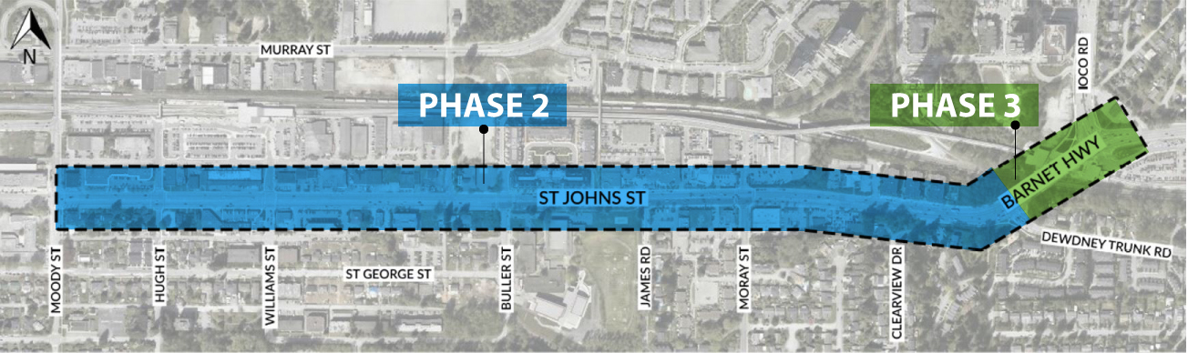
In the second phase a concept design is being developed for the section between Moody Street and Dewdney Trunk Road that identifies a long-term cross section, to be achieved over time as redevelopment and capital projects occur. It envisions:

  • four general purpose travel lanes;
  • two HOV lanes allowing for parking during non-rush hour times;
  • high quality separated bicycle facilities, and wide sidewalk facilities; and
  • landscaped boulevards.

This long-term cross section is designed to meet multiple transportation objectives for the corridor. The four general purpose lanes maintain existing traffic capacity while the rush regulation HOV lanes support efficient use of the road and improve bus speed and reliability during peak periods, while providing street parking during off peak times. A new separated bike path would close a gap in the cycling network and provide an All Ages and Abilities (AAA) connection along this route. In addition, the proposed landscaped boulevards and wider sidewalks are designed to enhance pedestrian comfort, support urban forestry goals, and contribute to walkability within the City’s transit-oriented development areas.

The existing St. Johns Street right-of-way is not consistently sufficient to construct the long-term cross section at this time. As such, the construction of the second phase is recommended in stages that prioritize rapid impact actions and consider timing of new development construction along the corridor. To deliver immediate safety, mobility, and transit priority benefits, the rapid implementation of the second phase focuses on improvements that can be delivered immediately within the existing right-of-way and maintaining the existing curbs, which includes:

  • switching the existing westbound HOV/parking lane to an eastbound HOV/parking lane to better serve HOV vehicle users and transit operations during afternoon peak hours;
  • installing a bi-directional protected bicycle lane on the north side of the corridor;
  • eliminating north side street parking (currently part-time parking outside of HOV hours) where required to accommodate the improved cycling facility. A limited amount of street parking will be maintained in locations where it is possible; and
  • providing right turn bays to maintain current westbound travel capacity.

These changes provide quick mobility benefits, including more reliable eastbound rush hour transit and HOV travel times and a protected cycling route that enhances safety and fills a critical network gap. Learn more about the proposed concept design presented to Council on April 21, 2026, agenda item 4.1.

Phase 3: Dewdney Trunk Road to Ioco Road (future planning)

The third phase focuses on improvements between Dewdney Trunk Road and Ioco Road to improve eastbound vehicle capacity and to extend the bike route connecting to Ioco Road and into Coquitlam. Work to complete the recommendations in this phase will be considered along with planned seismic retrofit work to the CPKC rail overpass on the Barnet Highway. 

Timeline

completed icon  Completed

  • Phase 1: Albert Street to Moody Street (completed in 2024)
    • construction of a new multi use path 
    • sidewalk, lighting, landscaping, and safety upgrades 
    • improved accessibility and pedestrian crossings

in progress In progress - (we are here)

  • Phase 2: Moody Street to Dewdney Trunk Road
    • conceptual design and traffic modelling 
    • review of eastbound rush hour traffic and key intersections 
    • coordination with future development and capital projects

not started  Not started

  • Phase 2: Moody Street to Dewdney Trunk Road
    • finalize the concepts for the long-term cross section, and improvements delivered in stages as development occurs
    • design and construction of the rapid implementation stage of the project
  • Phase 3: Dewdney Trunk Road to Ioco Road
    • planning for traffic improvements and future walking and cycling connections to Coquitlam

Contact

Engineering
604.469.4619